Google Maps is launching a few new features today, and, after a decade of trying, Google is finally launching Street View in India. What took so long?!
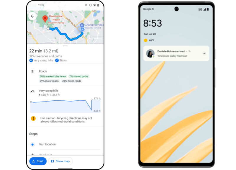
First up, we have a few new features from Google's latest blog post. Cyclists will now see a lot more information explaining what a route will be like. Maps now breaks down a route by percentages, showing how long you'll be in a marked bike line, a shared path, on a steep hill, or on a major road. The route selection screen is also able to break down routes into categories like "more bike lanes" and "less turns."
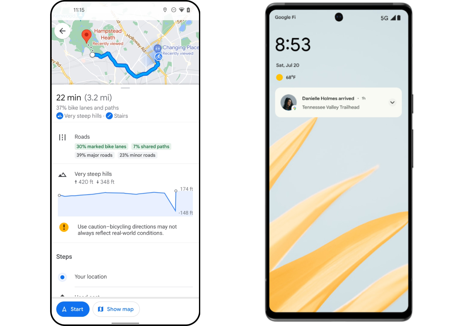
Location sharing is now getting notifications. If any friends or family members share their location with you, you'll soon be able to watch a certain area and get notified when they arrive or leave. Google imagines that if you're all meeting up somewhere, you can flag that location and get a push notification when each person arrives. This would also be great to know when someone lands at an airport.
As always, location sharing is a tricky privacy balance, so here's what Google says:
We’ve built this feature with privacy at the forefront. Notifications can only be set for someone who has already chosen to share their location with you. The person who’s shared their location with you will receive multiple reminders to let them know—including both a push notification in the Maps app and an email, along with recurring monthly emails. As always, you’re in control: you choose to stop sharing your location or block someone from setting notifications altogether.
The SimCity-like Immersive View is launching... maybe?
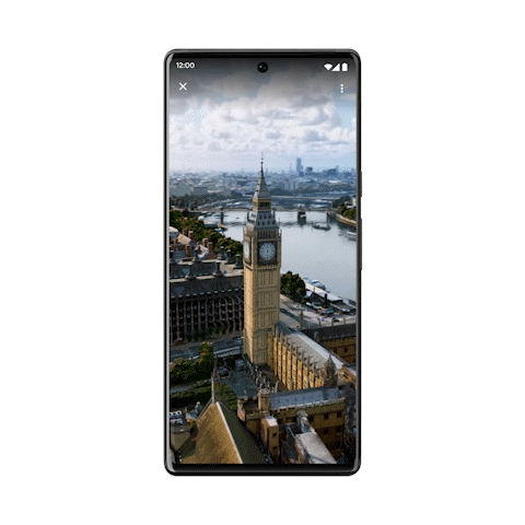
Google is also launching "photorealistic aerial views of nearly 100 of the world’s most popular landmarks." Google's blog post is not super clear about what we're getting. What is clear is that we're finally getting some kind of 3D, Google-Earth-style imagery on a phone, which previously wasn't possible in the mobile Google Maps app. There is a "3D" button on desktop Google Maps, which launches the Google Earth dataset, but on mobile you've only ever had a flat satellite view or untextured 3D blocks of buildings. Google Earth has its own app on mobile, which previously made a lot more sense because it takes an incredible amount of compute power, which your phone didn't necessarily have.
The big question, though, is: "Is this Immersive View"? Google previously announced "Immersive View" at Google I/O as a super-ambitious new detail layer for desktop and mobile Google Maps, which raises the graphical fidelity to new heights. The feature basically turns the service into SimCity, with simulated, animated 3D traffic, realistic water reflections, animated birds, clouds, and time-of-day lighting. Google does not say that Immersive View is launching soon, but instead that this new 3D feature is "the first step toward launching immersive view." That makes it sound like this feature is somehow more limited than Immersive View, but then Google's gif detailing the feature contradicts that statement by showing the exact same London Immersive View footage that was demoed at I/O. You can see moving cars, clouds and weather, reflective water, and shadows. That sure looks like Immersive View to me. We'll have to see what rolls out.
Street View is finally coming to India
Lastly, Google Maps Street View is finally coming to India. India is the world's second-largest population and a major focus for Google, so it might be surprising to hear that Street View didn't already exist there. Google hasn't been allowed to launch Street View in India for the last decade. Google originally tried launching the service in India in 2011, but the objections from the Indian government put an end to Google's data collection. Google tried again in 2016 by submitting plans to the government, but they were again rejected. Both times the government cited concerns about photographing "sensitive defense installations," and Street View never got off the ground. (Google blurs out tons of map data by request in other countries, but for some reason, that wasn't an acceptable solution.) The reason for the sudden relaunch of Street View is a new Indian geospatial policy that launched last year. Google still isn't allowed to collect data, but it can now license that data from local companies.
Licensing the data is not the standard operating procedure for Google. That's certainly how Maps got started, but today, Google prefers to collect everything itself, because that data is a huge competitive advantage. If you include contractors, Google Maps is Google's largest division by headcount. The company employs an army of Street View drivers and other Maps data collectors to map the entire world. Owning all this map data doesn't just let Google deny access to direct competitors, it also lets Google resell the data to any developers who need to build mapping functionality into their apps.
Google still isn't allowed to collect geospatial data in India, though. So Google now has two partners in the country, companies called Tech Mahindra and Genesys. Street View in India is first launching in 10 cities, and Google plans to map 50 Indian cities by the end of the year. Because this data is also available to other competitors, though, local service MapmyIndia is also launching 360°-image views along roughly the same trajectory.
All of this is supposed to launch "in the coming weeks."
Listing image by Google
reader comments
36